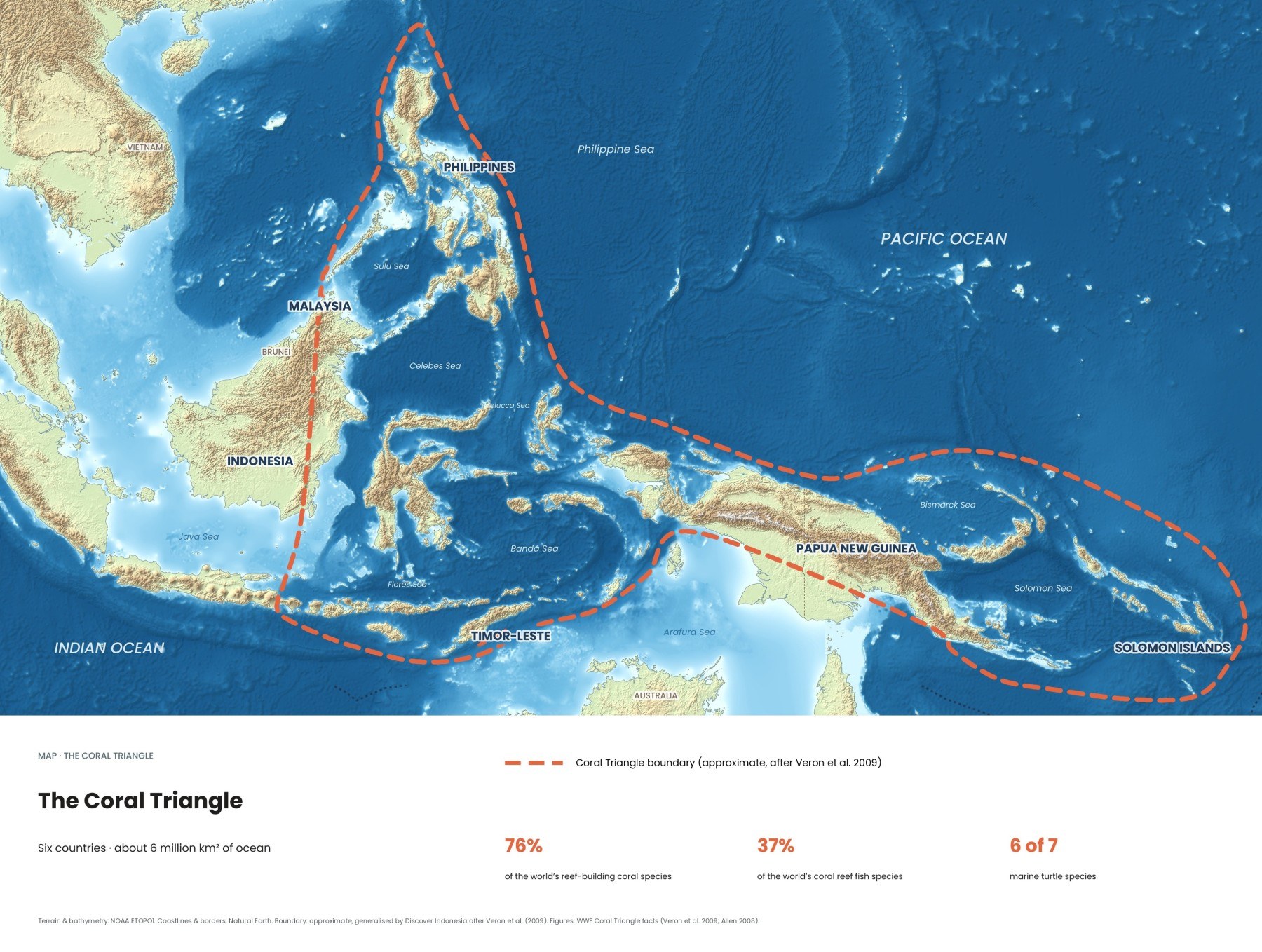
Coral reefs get the attention, but they don't work alone. Behind almost every healthy reef in the Coral Triangle lie seagrass meadows and mangrove forests that feed it, shelter its young fish, store carbon and protect the coast. Indonesia holds more mangrove forest than any other country. These maps show where all three habitats are, and where you can see them.
How do coral reefs, seagrass and mangroves work together?
They form a chain from land to open sea, and each link protects the next. Mangroves trap mud and nutrients coming off the land, seagrass slows the water and holds the seabed in place, and the reef breaks ocean swell before it reaches the shore. Young fish use the calm inshore habitats as nurseries, then move out to the reef as adults. Lose one and the other two weaken.
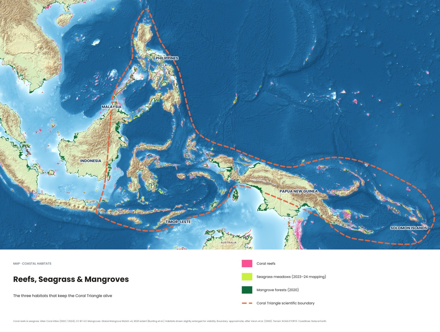
The relationship runs both ways. Mangroves and seagrass need the reef's shelter to grow in calm water, and corals need the clear, nutrient-poor water that mangroves and seagrass help create. Where all three sit side by side, as along parts of Papua, Borneo and the Philippines, marine life is at its richest.
| Habitat | Main job in the system | Where to see it in Indonesia |
|---|---|---|
| Mangroves | Trap sediment, buffer storms, fish nursery, carbon store | Raja Ampat, Bali's Tahura Ngurah Rai, coasts of Papua and Kalimantan |
| Seagrass | Stabilise the seabed, feed dugongs and turtles, nursery | Mali Beach on Alor, sheltered bays across eastern Indonesia |
| Coral reefs | Break swell, hold most of the fish diversity | Raja Ampat, Komodo, Wakatobi, North Sulawesi, Bali |
Every shallow reef, mapped from space
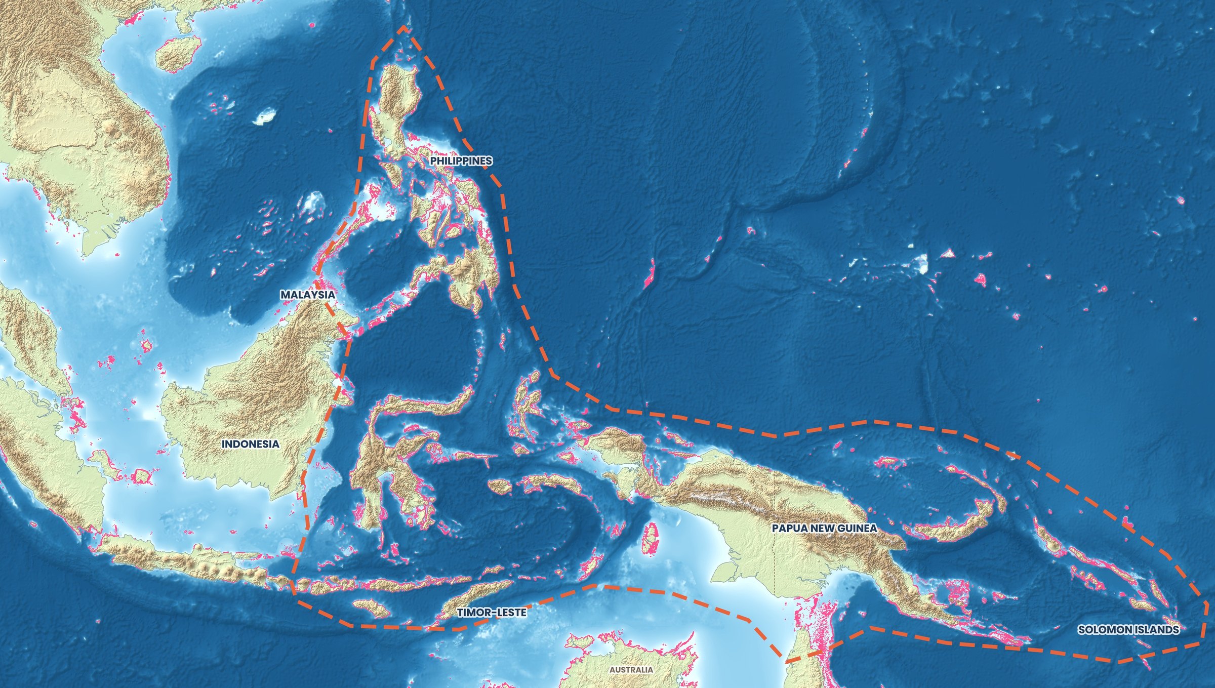
The Allen Coral Atlas mapped the world's shallow tropical reefs from satellite imagery. On this map, every pink line is reef, crowding around Sulawesi, the Lesser Sunda Islands from Bali to Timor, the Philippines and the islands of Papua New Guinea and the Solomons.
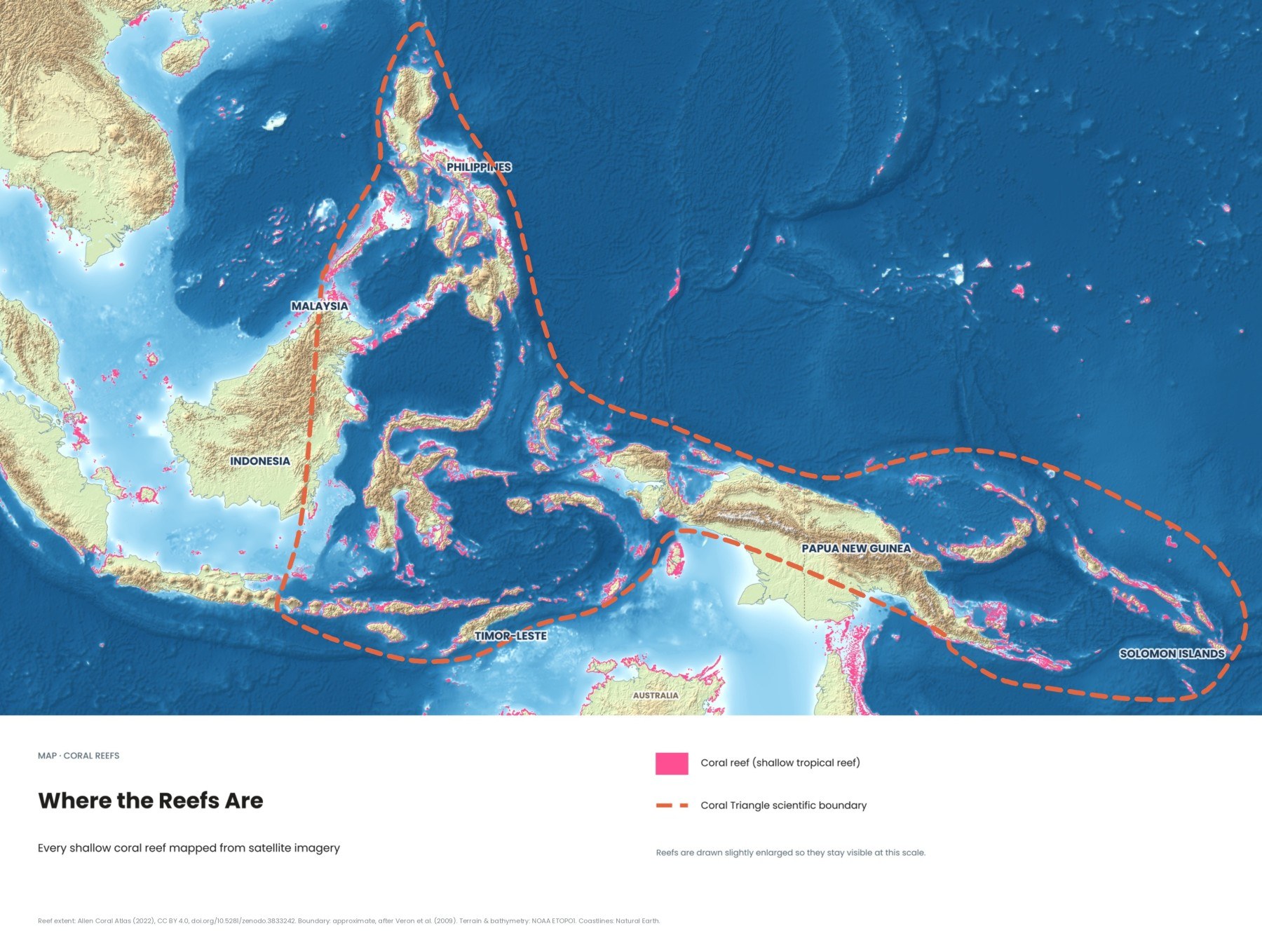
The atlas only maps reefs that satellites can see, down to roughly the depth where light still reaches the bottom clearly. Deeper reefs, and reefs under turbid river plumes, are under-represented. Our water clarity map shows where murky water hides the seabed.
Why are mangroves and seagrass called fish nurseries?
Because many reef fish spend their juvenile stage there before moving to the reef. The tangle of mangrove roots and the dense blades of seagrass give small fish food and cover from predators that patrol open reef. The clearest evidence comes from a 2004 Nature study by Peter Mumby and colleagues in the Caribbean: where reefs were connected to mangroves, the biomass of several commercially important fish species more than doubled. The authors recommended protecting connected corridors of mangrove, seagrass and reef rather than reefs alone.
What do dugongs have to do with seagrass?
Everything. Dugongs are the only marine mammals that eat nothing but seagrass, up to about 30 kilograms a day for an adult, so they can only live where healthy meadows exist. They breed slowly, a female having one calf every three to seven years, which makes populations slow to recover from hunting, nets or habitat loss. The IUCN lists the species as Vulnerable, and dugongs are protected under Indonesian law. Indonesia's seagrass itself is poorly mapped, the least visible habitat and the easiest to lose.
The most reliable place to see a wild dugong in Indonesia is Mali Beach on Alor, near Kalabahi, monitored by WWF Indonesia since 2016. In 2025 the first documented dugong calf there was filmed swimming with two adults. Experts warn that unregulated tourism is a risk, so use a local operator who keeps one boat at a time, cuts the engine at a distance and lets the dugong decide whether to approach. Do not touch, feed or swim after it. See our Alor diving guide.
What is blue carbon, and why do mangroves store so much?
Blue carbon is the carbon stored by coastal and marine ecosystems, mainly mangroves, seagrass and salt marshes. Mangrove soils are waterlogged and low in oxygen, so dead roots and leaves decompose very slowly and carbon builds up in the mud for centuries. A 2015 study led by Daniel Murdiyarso found a national stock of about 3.14 billion tonnes in Indonesian mangroves, and estimated that stopping their loss could cut the country's land-use emissions by 10 to 31 percent. Seagrass matters too: according to the UN Environment Programme, meadows cover only about 0.2 percent of the sea floor but account for around 10 percent of the ocean's capacity to store carbon.
How much mangrove forest does Indonesia have, and how much has been lost?
More than any other country. Indonesia's 2025 National Mangrove Map, adopted in December 2025, records 3,455,628 hectares, roughly 20 percent of the world's mangroves. The largest forests are in the east, led by South Papua with about 622,000 hectares.
The long-term picture is one of heavy loss, driven above all by shrimp ponds. Global Mangrove Watch, updated in 2026 to cover 1985 to 2025, shows Indonesia lost 2,043 square kilometres of mangroves since 1985, more than any other country in the dataset, though its extent has been more stable since 2015. A national rehabilitation drive began after 2020. Restoration works best when the original tides and water flow are restored, often by reopening abandoned shrimp ponds, rather than by planting seedlings on mudflats where mangroves never grew.
Where can travellers see all three habitats in Indonesia?
Raja Ampat is the best place to see mangroves, seagrass and reef together, often on a single snorkel. It is famous for blue-water mangroves, where clear ocean water reaches into the forest and corals grow among the roots. At The Passage, a narrow channel between Gam and Waigeo, divers drift past roots covered in soft corals and sea fans. Snorkel these sites near high tide. Our Raja Ampat diving guide covers the main areas.
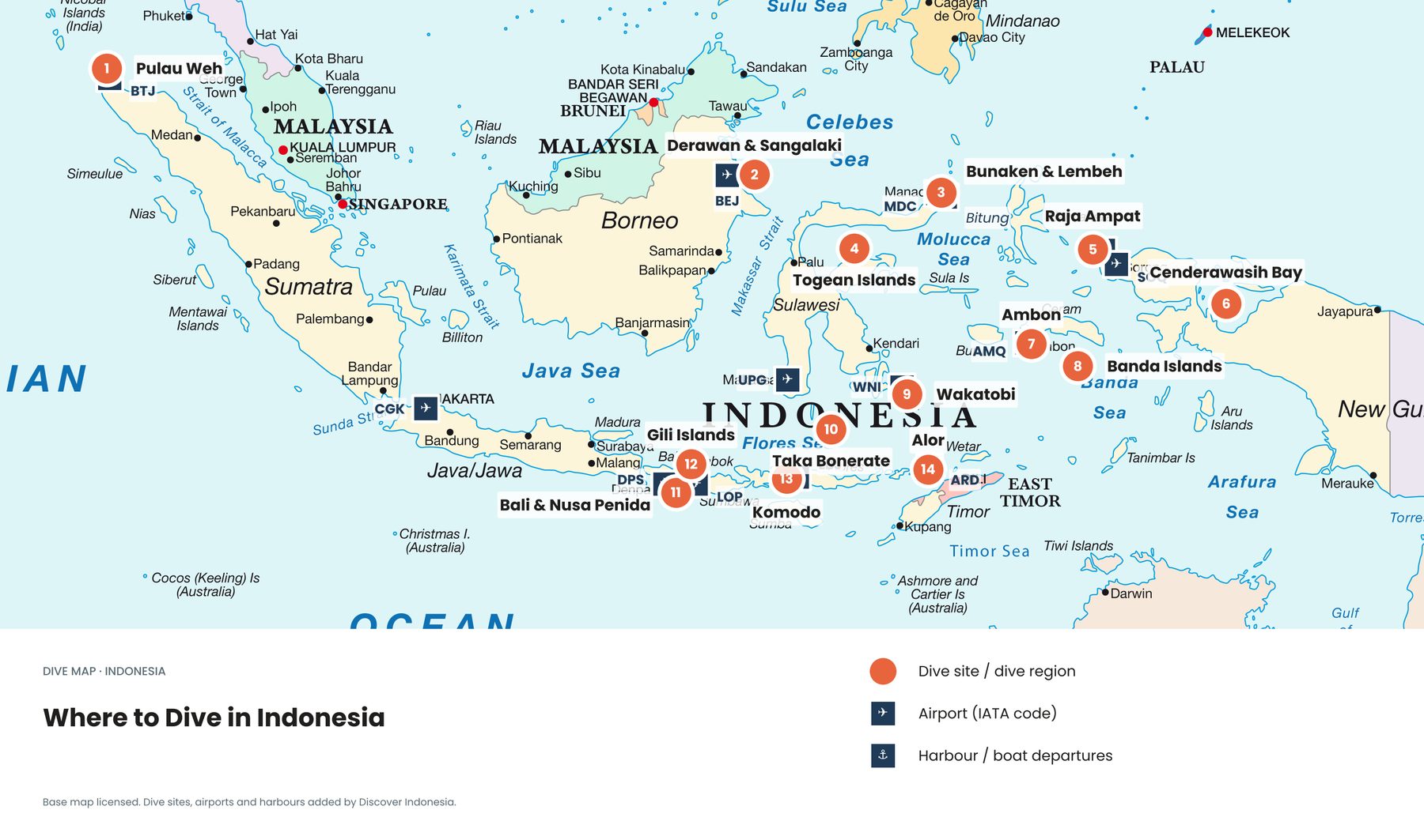
Alor combines Mali Beach's seagrass and dugongs with the reefs of the Pantar Strait. In Bali, the Tahura Ngurah Rai mangrove forest around Benoa Bay lies minutes from the airport; part of it was ponds rehabilitated since 1992. Go early or late, when birds are active. See our Bali diving guide and Indonesia's dive regions on one map.
How do you visit these habitats without damaging them?
Stay off the bottom and give wildlife space. Float or swim over seagrass and reef flats, because fin kicks in shallow water rip out seagrass and stir up sediment that settles on corals. Go near high tide in mangroves so you are not forced to kneel on the bottom. Watch dugongs and turtles from a distance and ask boats to cut their engines well away. Avoid boats that anchor on seagrass or coral, and take your rubbish back, since mangroves catch floating plastic.
Quick answers
Is seagrass a type of seaweed?
No. Seagrasses are flowering plants that grow in shallow, sheltered water, where green turtles and dugongs graze.
Where can I see a dugong in Indonesia?
Mali Beach on Alor, near Kalabahi, is the most reliable place. Allow spare days, since sightings are never guaranteed.
What threatens these habitats now?
Coastal development, aquaculture, sediment, pollution and warming seas, as the 2024 bleaching event showed. Oil collects in sheltered shallows where mangroves and seagrass grow; see our map of oil slicks around the Coral Triangle.
Protection works best when it covers the whole chain from forest to reef; our map of marine protected areas shows where that is happening. Our Coral Triangle and diving guides cover these regions in more depth. Browse all our guides, or see all eight Coral Triangle maps →
Facts checked October 2026. Mangrove figures are revised every year, and dugong-watching rules on Alor are still evolving; check the latest with the Ministry of Environment, WWF Indonesia and local operators before you travel.
- Allen Coral Atlas: reef extent 2022, seagrass 2023–24, CC BY 4.0 (Allen Coral Atlas)
- Good news for mangroves globally masks big losses in some regions (Wetlands International / Global Mangrove Watch, 2026)
- Indonesia's mangrove coverage expands to 3.45 million hectares (RRI, January 2026)
- Indonesia's mangroves account for 20.37% of the global total (Katadata, National Mangrove Map 2021)
- Balancing biodiversity and disaster mitigation efforts with mangroves (Antara, 2023)
- The potential of Indonesian mangrove forests for global climate change mitigation (Murdiyarso et al., Nature Climate Change, 2015)
- Mangroves enhance the biomass of coral reef fish communities in the Caribbean (Mumby et al., Nature, 2004)
- Seagrass, the secret weapon in the fight against global heating (UN Environment Programme)
- Rare dugong calf sighting in Alor spotlights seagrass conservation (Mongabay, 2025)
- Dugongs and their habitats need urgent attention (WWF Indonesia)
- Dugong tourism in Alor: can it be regulated for sustainability? (WWF Indonesia)
- Dugong facts (Great Barrier Reef Foundation)
- Landscapes and seascapes of Raja Ampat (WWF Coral Triangle blog)
- Raja Ampat in the off season (Divernet)
- Presiden Jokowi tinjau hutan mangrove di Bali (Cabinet Secretariat of Indonesia, 2021)
- Global Mangrove Watch v4, 2020 extent (Bunting et al.). Boundary: approximate, generalised by Discover Indonesia after Veron et al. (2009). Terrain: NOAA ETOPO1. Coastlines: Natural Earth