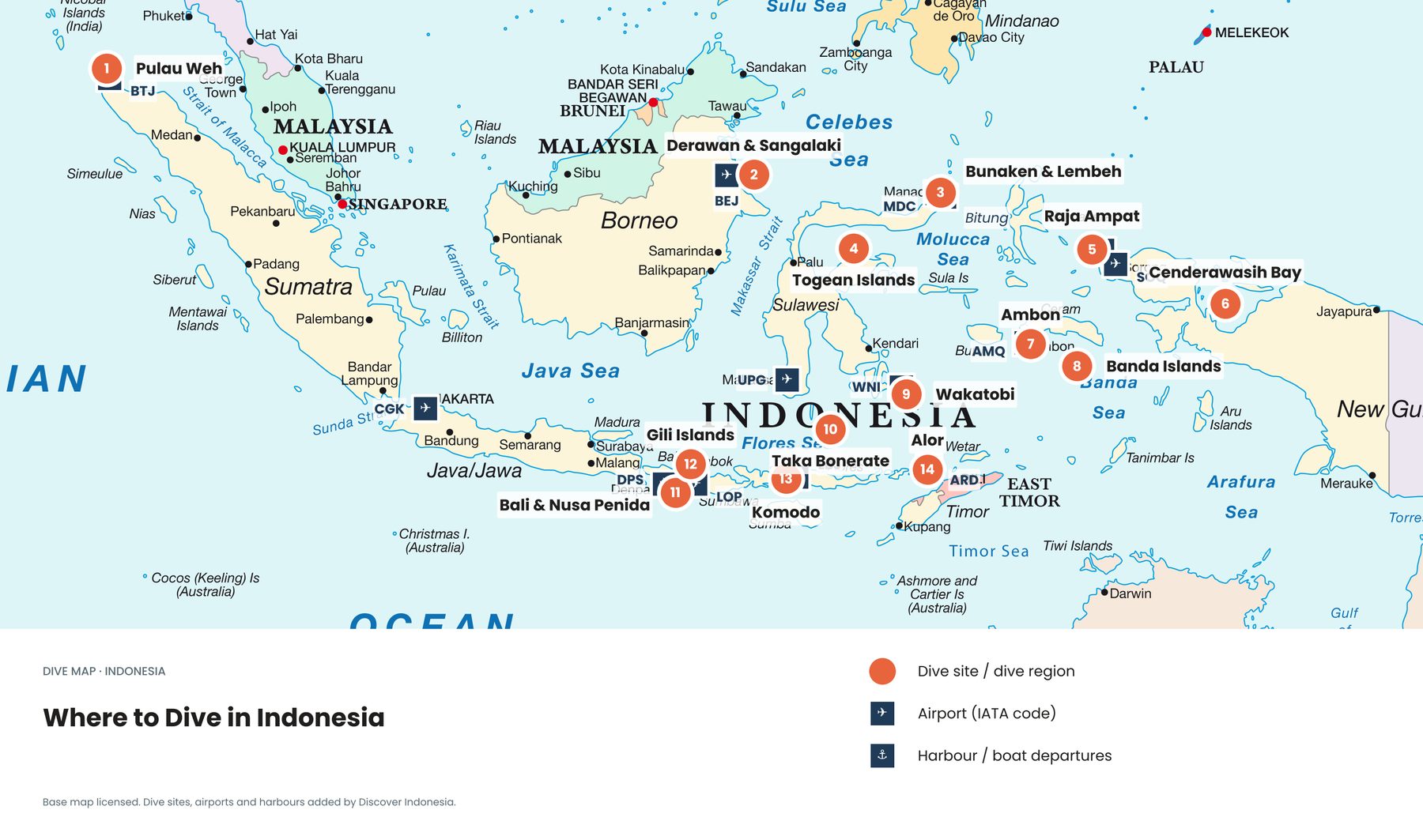
Between the Pacific and the Indian Ocean lies a stretch of sea holding three quarters of the world's coral species. Scientists call it the Coral Triangle. Indonesia holds the largest part of it, and these eight maps show where the reefs are, what keeps them alive and what puts them at risk.
What is the Coral Triangle?
The Coral Triangle is the area of ocean with the highest coral diversity on Earth, about six million square kilometres across Indonesia, Malaysia, the Philippines, Papua New Guinea, Timor-Leste and the Solomon Islands. According to WWF, it holds 605 of the world's 798 known reef-building coral species, or 76%, and around 2,228 coral reef fish species, about 37% of the global total. The richest corner is the Bird's Head Peninsula of West Papua, with 574 coral species, 553 of them in Raja Ampat alone.
Its border was not drawn by politicians. Coral scientists led by J.E.N. Veron traced a line around the waters holding more than 500 reef-building coral species, published in 2009. It does not follow national borders, which is why it slices through Indonesia and leaves Java, Sumatra and most of Borneo outside.
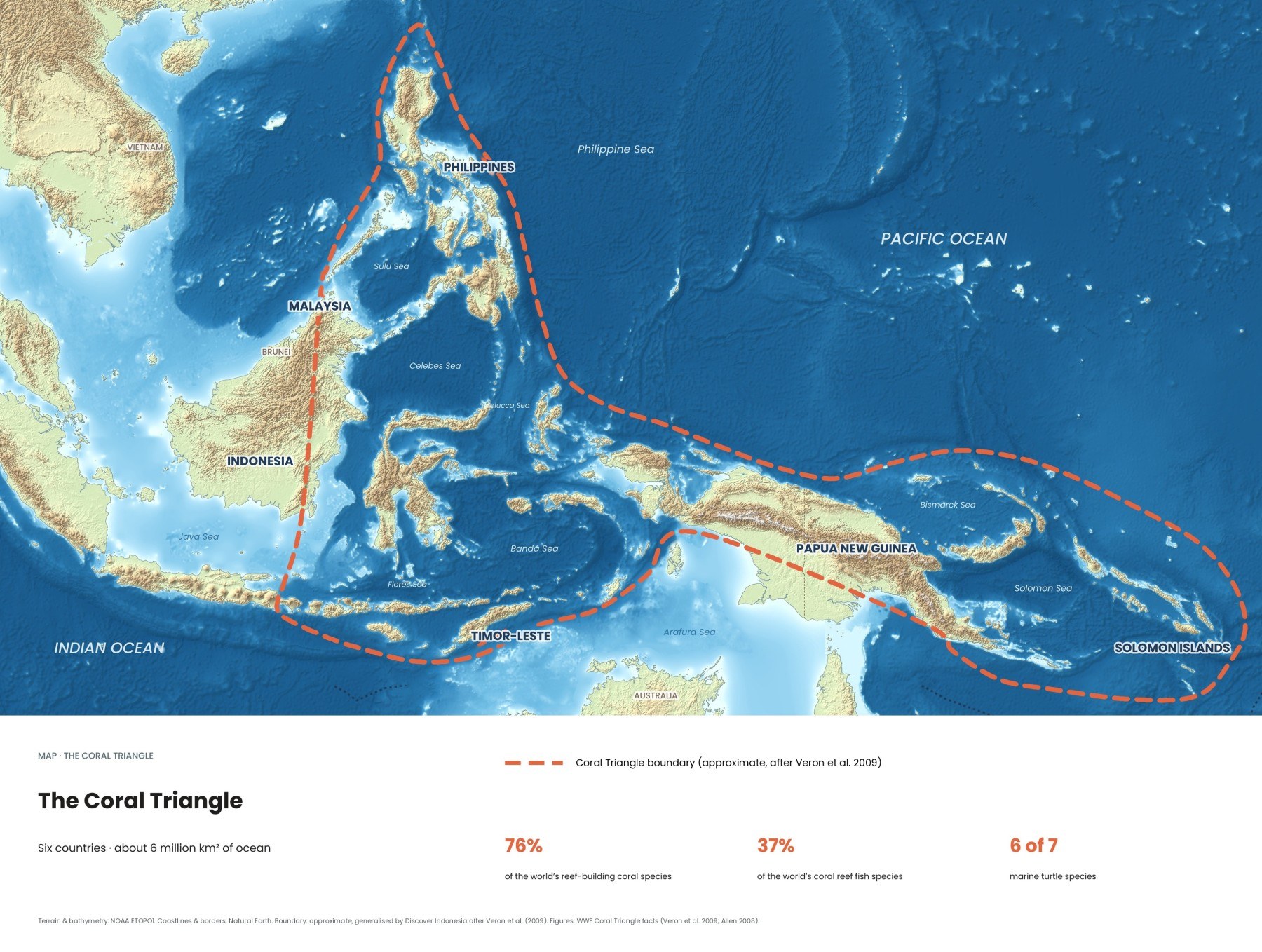
Bali sits right on the western edge: the reefs of Nusa Penida and the east and north coasts fall inside it. The six governments manage the region together through the Coral Triangle Initiative (CTI-CFF), founded at a summit in Manado on 15 May 2009, which works across their whole national waters. WWF puts the number of people who depend on these coasts and seas at more than 120 million.
Where are the Coral Triangle's reefs?
Most of the shallow reefs crowd around Sulawesi, the Lesser Sunda Islands from Bali to Timor, Maluku and the coasts of West Papua, the Philippines and Papua New Guinea. Every pink line on this map is a shallow reef traced from satellite imagery by the Allen Coral Atlas, which finished the first complete high-resolution map of the world's shallow tropical reefs on 8 September 2021.
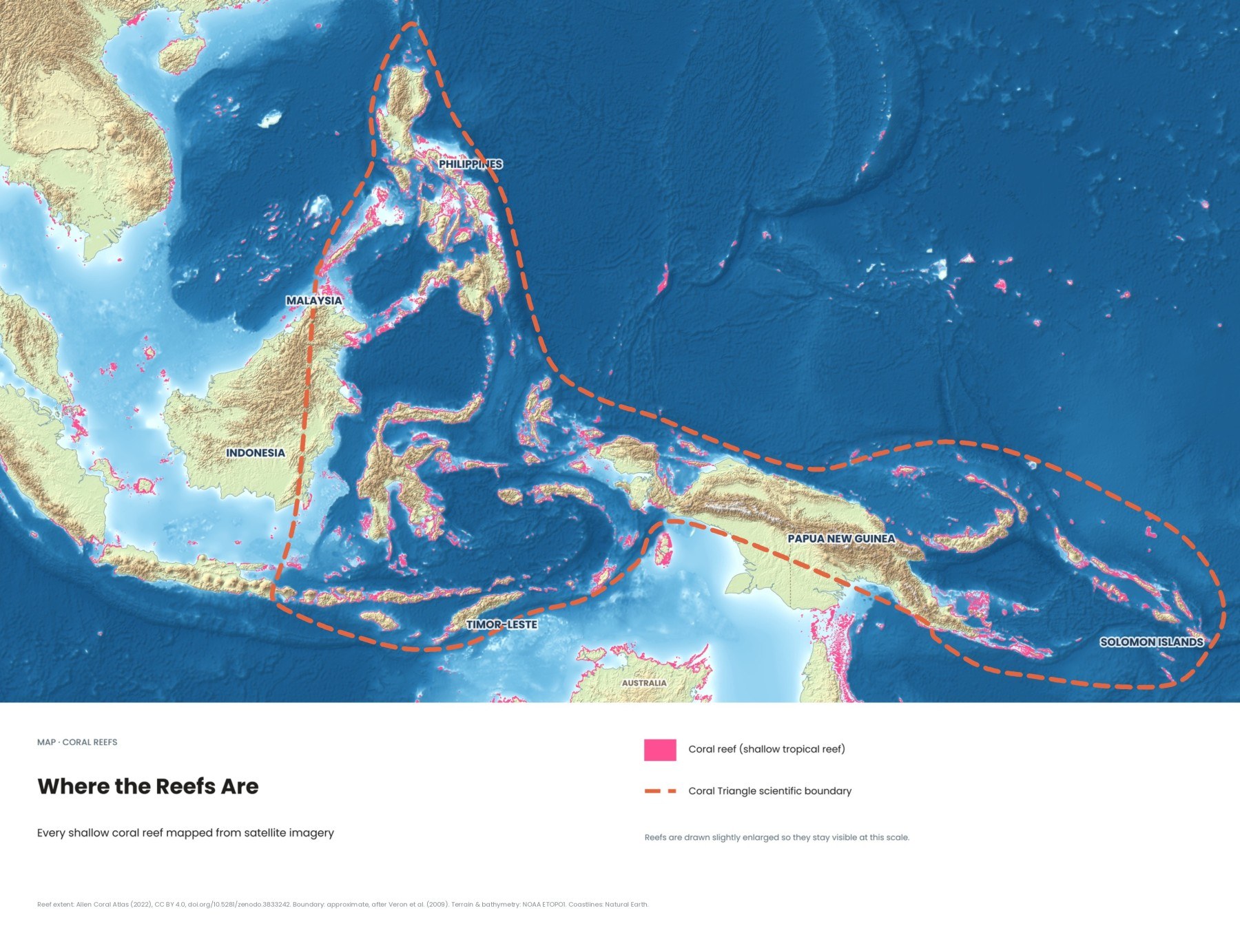
Reefs fringe almost every coast in eastern Indonesia, because the islands are steep, volcanic or uplifted limestone with little river mud. Long barrier and atoll systems sit offshore in places like the Flores Sea, where Taka Bonerate forms one of the largest atolls in the world. The shallow Java Sea and Sunda Shelf to the west have far fewer reefs, one reason the boundary stops where it does.
Why does so much ocean flow through Indonesia?
Because the western Pacific sits slightly higher than the Indian Ocean, and the gaps between Indonesia's islands are the only tropical route between the two. About 15 million cubic metres of water per second push through on average, a current called the Indonesian Throughflow.
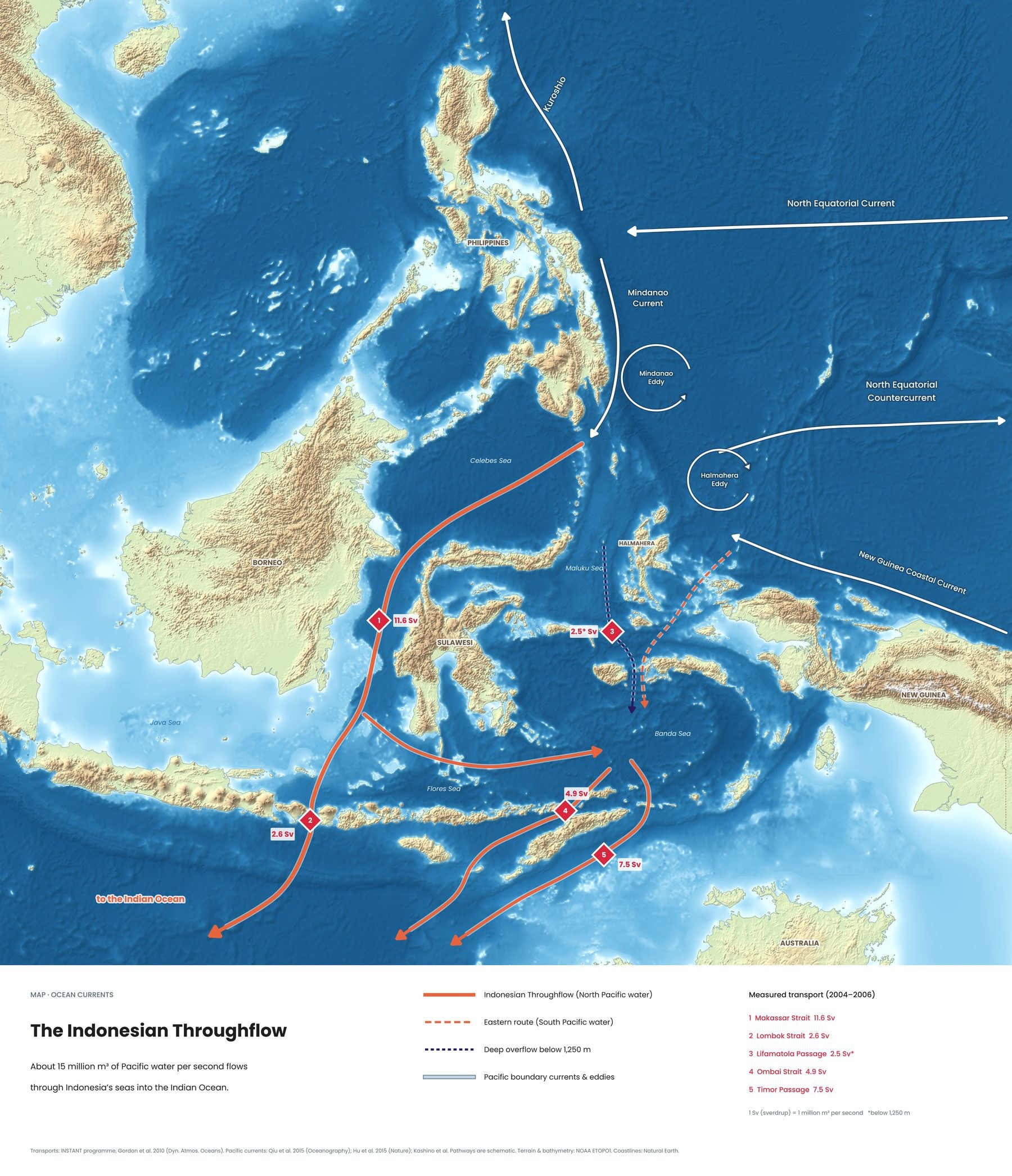
| Passage | Average flow (INSTANT) | What it means for divers |
|---|---|---|
| Makassar Strait | 11.6 Sv inflow | The main highway, between Borneo and Sulawesi |
| Lombok Strait | 2.6 Sv outflow | Runs past Nusa Penida: cold upwellings, mola mola, fast drifts |
| Ombai Strait | 4.9 Sv outflow | Passes Alor: cold, clear water and strong currents |
| Timor Passage | 7.5 Sv outflow | The widest exit, south of Timor |
The flow is strongest from June to August, during the southeast monsoon, and weakest around April. Divers feel it directly: Nusa Penida's coldest water and best mola mola season fall in the strong-flow months, and Komodo's southern sites drop to around 20 to 24°C from July to September. More in our article on the Indonesian Throughflow.
Why do reefs need seagrass and mangroves?
Because the three habitats work as one system. Mangroves trap sediment and shelter young fish, seagrass meadows feed turtles and dugongs and serve as nurseries, and reefs provide the structure where adult fish live. Where all three sit side by side, as along the coasts of Papua and Borneo, marine life is at its richest.
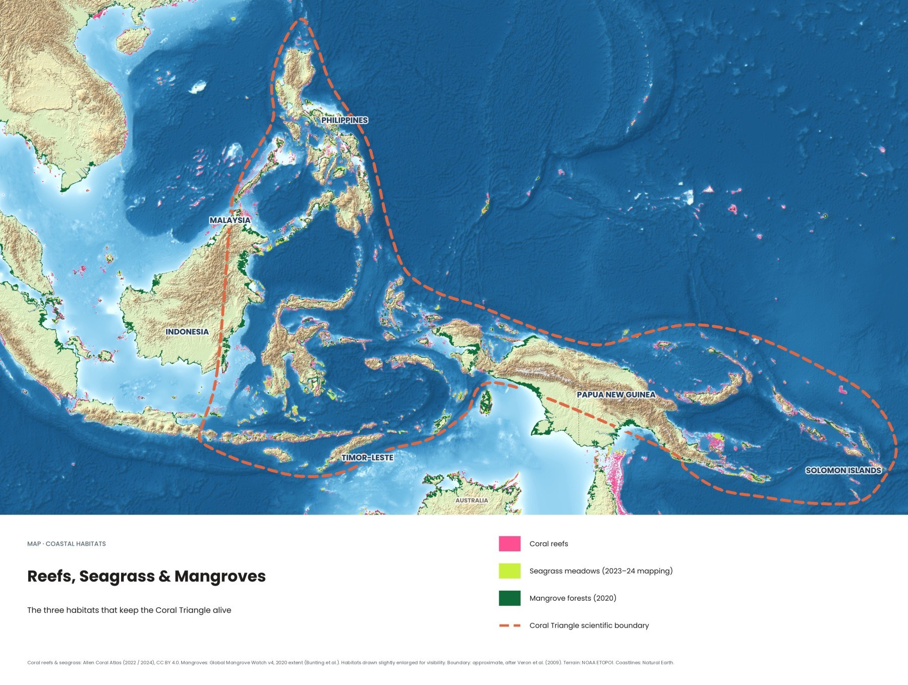
Indonesia has more mangrove forest than any other country, about 2.95 million hectares according to Wetlands International, more than 20% of all that is left on Earth. More than half is degraded, mostly cleared for aquaculture ponds, farming and development. A green turtle grazing in two metres of water in the Gili Islands or Komodo is almost certainly feeding on seagrass. See our article on reefs, seagrass and mangroves.
Where is the water clearest in the Coral Triangle?
On this map, the clearest shallow reef water is in the Solomon Islands, around eastern Papua New Guinea and in parts of the central Philippines. The murkiest is near big rivers, cities and heavily farmed coasts, such as Sumatra and eastern Borneo. The map shows the 2025 median turbidity over each shallow reef, from Sentinel-2 satellite data processed by the Allen Coral Atlas.
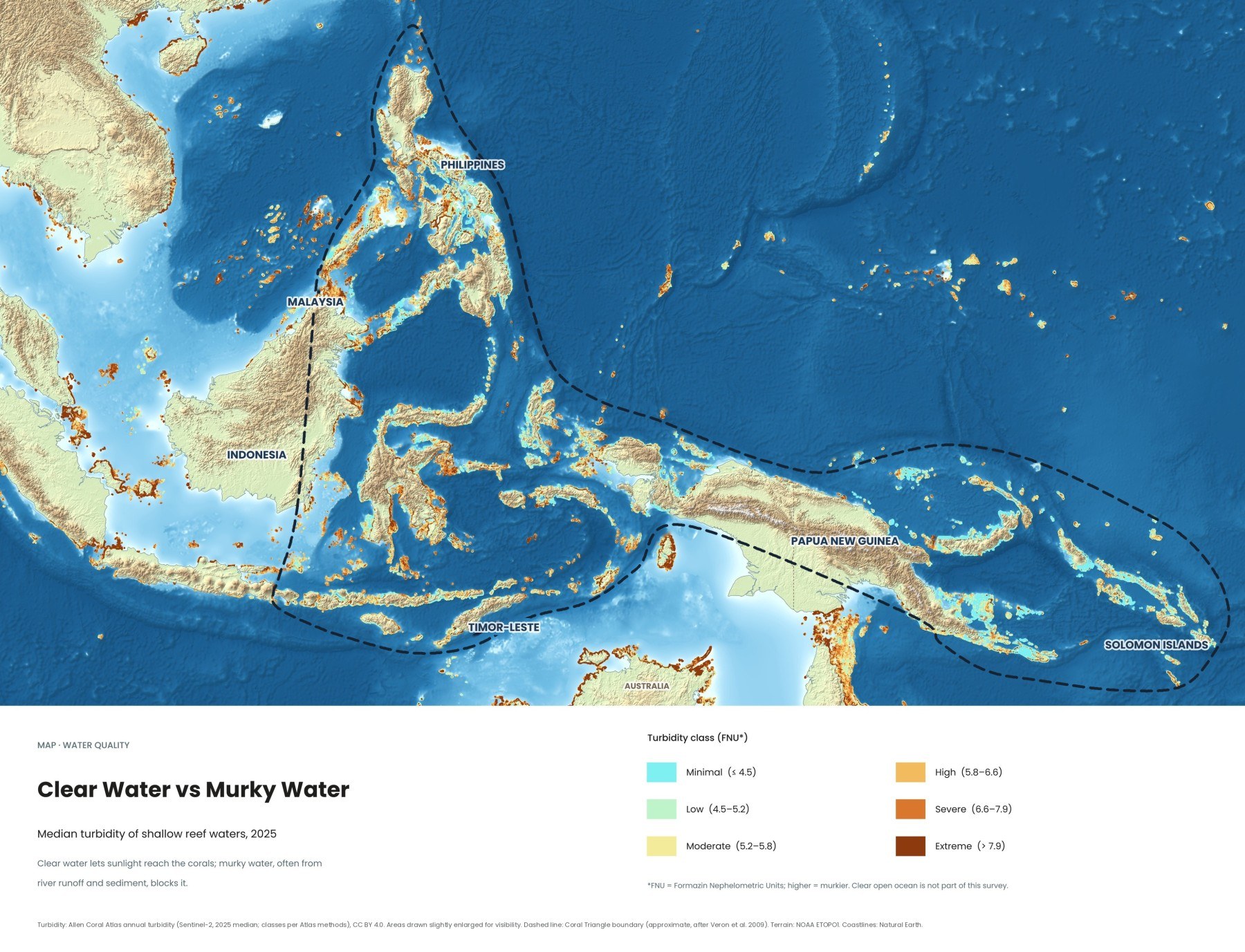
Much of Indonesia shows up orange. The survey measures the shallow water on top of reefs, including reef flats close to shore, not the deep blue off a wall. Sediment blocks the light corals need. Murky does not always mean bad diving, though: the Lembeh Strait is famous for its frogfish and nudibranchs, not its visibility. More in clear and murky water across the Coral Triangle.
How did the 2024 ocean heatwave affect the Coral Triangle?
The 2024 heatwave pushed much of the Pacific side of the region past the bleaching threshold, while parts of central and eastern Indonesia stayed below alert levels that year. It was part of the fourth global coral bleaching event, confirmed by NOAA on 15 April 2024. By the time it likely ended in mid-2025, about 84% of the world's reef area had experienced bleaching-level heat stress.
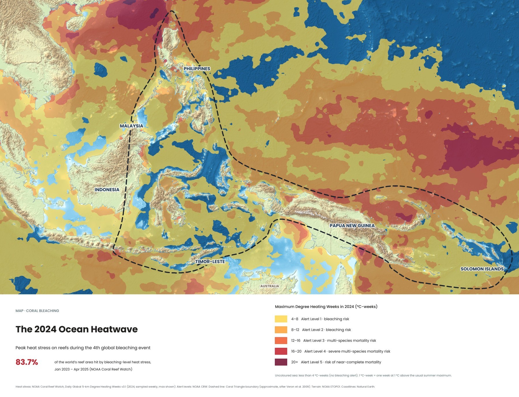
The map uses NOAA's Degree Heating Weeks (DHW): one DHW is one week at 1°C above the normal summer maximum, and from 4 DHW NOAA issues Alert Level 1. The deepest reds sit in the open Pacific north and east of Papua New Guinea and in the northern South China Sea. Much of the Banda, Molucca and Flores Seas stayed below 4 DHW. Heat stress is not the same as damage, and a bleached coral can recover if the water cools in time. Read more on the 2024 heatwave and coral bleaching.
Is oil pollution a threat to the Coral Triangle?
Yes. Chronic oil discharges from ships are spread across the region's busiest sea lanes, and a much larger risk comes from planned oil and gas development. SkyTruth's Cerulean system scans Sentinel-1 radar images, where oil shows as a dark streak on rippled sea. Between August 2020 and October 2026 it detected 23,036 slicks across the region shown, about 13,000 inside the Coral Triangle, most probably from vessels discharging oily waste.
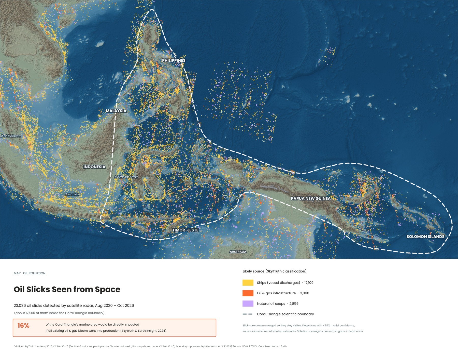
The densest lines trace the Strait of Malacca, the Java Sea and the Makassar Strait. A 2024 report by Earth Insight and SkyTruth found more than 100 offshore oil and gas blocks already producing in the Coral Triangle and more than 450 more earmarked for exploration, overlapping 24% of its coral reefs if all went ahead. In February 2023 the tanker Princess Empress sank off the Philippines, affecting 20 marine protected areas. See oil slicks seen from space.
Which parts of the Coral Triangle are protected?
A growing network of marine parks covers many of the best reefs, including Raja Ampat, Komodo, Wakatobi, Bunaken, Taka Bonerate, Nusa Penida, the Gili Islands and Cenderawasih Bay in Indonesia, and Tubbataha and Apo Reef in the Philippines. Indonesia's marine conservation areas covered about 8.9% of its seas in early 2024, and the government aims to reach 30% by 2045.
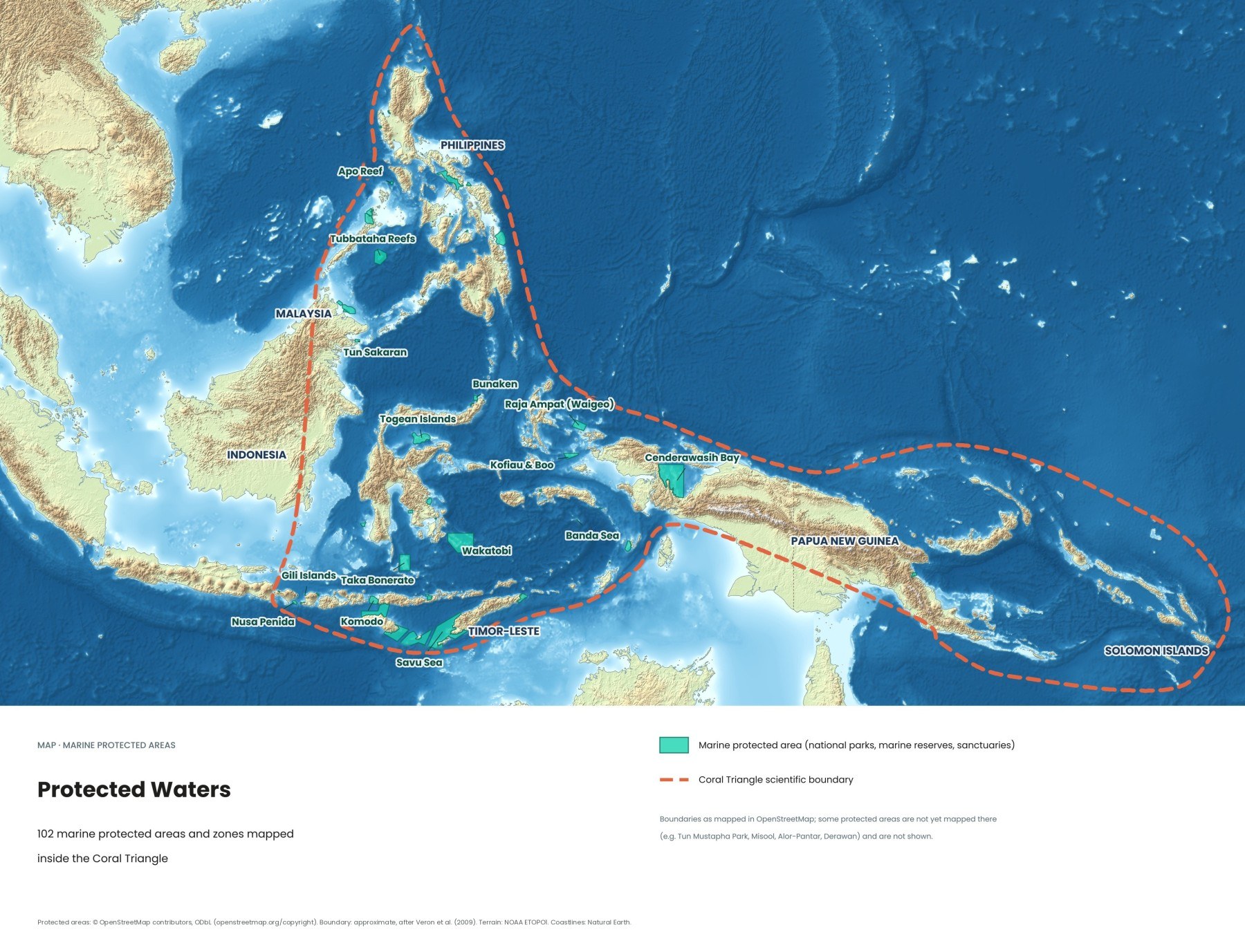
Komodo National Park became a UNESCO World Heritage Site in 1991, Tubbataha Reefs in 1993. Protection on paper is not protection in the water: what works is rangers, patrol boats, mooring buoys and no-take zones. Park fees in Raja Ampat, Komodo and Wakatobi pay for patrols and community programmes, so pay them gladly and keep the receipt or tag on you. Our article on the protected waters lists the parks one by one.
Quick answers
Where can I see the Coral Triangle for myself?
Bali's Nusa Penida, 35 to 45 minutes by fast boat from Sanur, is the easiest start. With a week, add Komodo from Labuan Bajo; with two weeks or more, go to Raja Ampat, Wakatobi or North Sulawesi.
Do I need to dive to see the Coral Triangle?
No. Many reefs in Raja Ampat, Komodo, Wakatobi, the Gili Islands and the Togean Islands start in less than five metres of water. Channels in Komodo and around Nusa Penida can be dangerous for swimmers, so snorkel from a boat with a crew watching.
How do I visit the Coral Triangle responsibly?
Do not touch or stand on coral, keep your distance from wildlife, pay the marine park fees, and choose operators that keep groups small and use mooring buoys instead of anchors.
Read more: the ten best places to see the Coral Triangle, the Coral Triangle vs. the Great Barrier Reef and all of Indonesia's dive regions. Our Coral Triangle, Raja Ampat and Wakatobi guides go deeper into routes and planning; all titles are on our guides page.
Facts checked October 2026. Park fees, permit rules and protected area boundaries change often; confirm current details with CTI-CFF, the relevant national park office or your dive operator before you travel.
- Coral Triangle facts (WWF)
- CTI gets $120m to protect marine environment (The Jakarta Post)
- Coral Triangle Initiative (Wikipedia)
- Allen Coral Atlas completes first global coral reef maps (Allen Coral Atlas)
- The Indonesian Throughflow during 2004–2006 as observed by the INSTANT program (Gordon et al. 2010, Dynamics of Atmospheres and Oceans)
- Indonesian Throughflow (Wikipedia)
- How Global Mangrove Watch empowers local action in Indonesia (Wetlands International)
- World's fourth mass coral bleaching event likely ended in 2025 (Down To Earth, reporting NOAA Coral Reef Watch)
- Coral biodiversity hotspot at risk from fossil fuel expansion, report warns (Mongabay)
- Coral Triangle threats and Cerulean (SkyTruth)
- Indonesia aims to expand marine protection area to 30 percent by 2045 (Tempo)
- Komodo National Park (UNESCO World Heritage Centre)
- Wakatobi National Park (Wikipedia)